The Green Revolution refers to the high yield of food grains such as Rice & Wheat, to transform the malnourished growing population. It all started in the 1950s and 60s when a set of technological transforming initiatives were carried worldwide, especially in the developing world. The new technology included high yield varieties of cereals, the use of pesticides and better management techniques. Policies of institutional support were introduced to cater to the Green Revolution such as subsidies for fertilizers and groundwater extraction, also Minimum Support Prices (MSP) for food grains and procurement for the processing plants (such as Rice Mills). From a malnourished nation, these steps made India an exporter of food grains. Today India is the world’s second-largest producer of wheat and rice after China.
However, The green revolution has its own set of demerits and in fact, the demerits may be overtaking the merits lately.
- Since its launch, the green revolution has failed to provide more nutritious food such as Millets because of its focus on a high yielding crop such as Rice.
- The subsidies in fertilizer have turned the highly fertile land into barren land.
- Excess extraction of water has depleted the groundwater level.
- Water-logging in fields and salinity increased due to excess irrigation.
Thus, to rectify the loopholes of the Green Revolution there was a dire need for new policies and innovations and hence the term “Evergreen Revolution” was coined by the father of Green Revolution, M.S. Swaminathan. The logic is to produce more from less, less land, less pesticide, less water and it must be an evergreen Revolution to get sustainable agriculture.
Role of Drones in Agriculture
THE FOLLOWING IS A RESEARCH BY UNIVERSITY OF DELAWARE, USA.
Rotary Drones
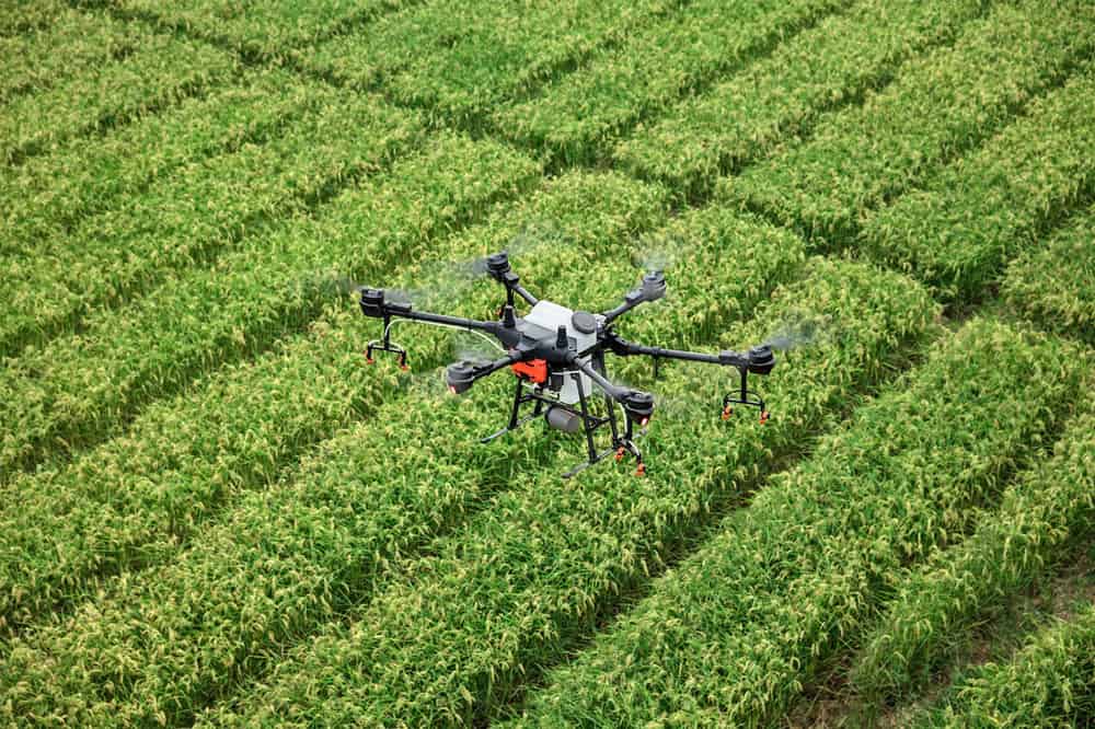
A rotary drone is often identified by the number of rotors (propellers). An example would be the quadcopter, which has four rotors.
A rotary drone is an excellent scouting tool for field crop operations. A quadcopter can takeoff land vertically, so field lanes and parking spots become launching zones. Rotary drones are easy to maneuver across the field and can hover over problem areas.
Battery life is an issue with rotary drones since power is drained more quickly due to the powering of multiple propellers. Flight times for many quadcopters range from 10-20 minutes and can be less when flown during high wind speeds. As such, rotary drones are useful for smaller fields and scouting operations.
Fixed Wing Drones
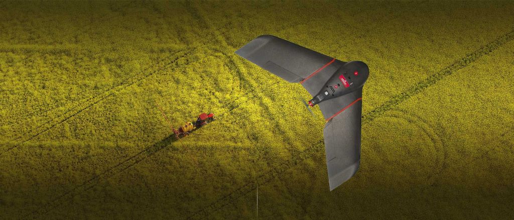
Fixed-wing drones work just like airplanes, using lift and drag to stay aloft; most fixed-wing drones have only one propeller. As a result, fixed-wing drones have longer battery lives, with the potential to stay in the air for 20 minutes or longer.
Fixed wings also can reach greater speeds than a rotary drone, and when combined with longer battery life, it allows fixed-wing drones to cover greater acreage.
However, fixed wings will require space to land, similar to an airport runway. They may be designed to land by skidding across the ground.
The hybrid version of a fixed-wing overcomes this issue by taking off and landing like a copter but flying like a fixed-wing.
Camera and Sensor Types
Many popular consumer drones come with their own cameras, which are good for photography or scouting. Drones advertised for measuring field crop health may be fitted with specialized cameras, often at a much higher cost than consumer drones. For agriculture, the necessary camera will be dependent on the end-user.
Visual Cameras
Cheaper consumer drones may come with a visual camera, sometimes called RGB (red-green-blue) camera. Like the human eye, these cameras will capture the visual spectrum, and therefore, work well for field scouting.
Multispectral Cameras
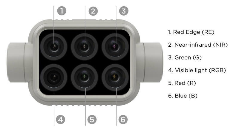
Plants reflect a larger range of wavelengths than our eyes can detect, including light in the near infrared region (NIR). One option to capture both visual and NIR bands is to make two flights with different cameras. Another option is to use a camera with multiple lenses.
Multispectral cameras have more than one lens, each with a different filter. These filters allow the lens to focus on selected wavelengths, including the NIR and visual spectrum. Images from multispectral cameras can be used to calculate vegetation indexes, which are correlated to biomass or plant health.
Thermal Cameras
Longer infrared wavelengths can be used to measure thermal radiation or temperature. Plants that are either dead or under stress should be warmer from less evaporation, which can be detected by thermal cameras.
LiDAR
Light detection and ranging (LiDAR) uses lasers to detect the distance of objects. These sensors are very accurate at mapping landscape elevations. They are also fairly expensive to deploy on drones. Elevation can also be measured with drones using overlapping images (also called photogrammetry), which could be done with a regular camera at lower cost, but with reduced accuracy when compared to LiDAR.
Other Potential Drone Accessories
Some drones may need additional parts, including remote controls, tablets, and software to properly fly the drone. It is wise to check the accompanying accessories before a purchase is made.
Cameras may also need additional parts, including a global positioning system (GPS) to tag photos and a light sensor to correct for varying weather conditions. These are only necessary for higher end users.
Vegetation Indexes
Within the agricultural drone market, there are many claims that drones can be used to measure crop health. In many cases, these companies are using multispectral data that observe how plants reflect different wavelengths of light. Many vegetation indexes that compare reflection were originally based off satellite photography and are well established. One of the most well known is the normalized difference vegetation index (NDVI). This index uses the NIR and red bands to determine plant biomass (Figure 4). However, the biomass being characterized by these methods may include weeds. If disease or insect damage is enough to reduce biomass, NDVI cannot necessarily inform a scout as to its actual presence, just that there is an issue. If potential issues are spotted using drone technology, we recommend that the field still be walked to determine the underlying cause of the issue. A trained agronomist can identify field issues from visual photos without the need for multispectral cameras.
Drones and Agriculture – A Match made in heaven
coming back to our discussion (after a long technical discussion about drones), combining all the features of a drone such as quick transportability, fast access to data through sensors its seems as if the drone handler himself is analyzing the field in real time.
Moreover, it removes much of the human error aspect of traditional inventory work by using data analytics and IoT. Though many will argue that ground-based inspections combined with satellite imagery, along with a dedicated grid soil sampling program is more practical to determine the NPK (Nitrogen, Phosphorus & Potassium) content of the farm, a Variable Rate Application Map of a field may show the amount of the nutrients to be applied in different parts of the field.
e.g. A farmer can apply 300 kg/ha of fertilizer to struggling areas, 200 kg/ha to medium quality areas, and 150 kg/ha to healthy areas,decreasing fertilizer costs and increasing yield. Also, it’s the drone that can assist in spraying the fertilizer with an efficiency of five times that of manual spraying.
In this modern age, scaling up productivity exponentially does not mean having more of the things you make but changing the way you make it. With the introduction of drones in the agricultural sphere is a great step to revolutionize the industry.
 Abhiraj Saraf